HISTORY OF
The Gilmore Mica Mine
by David H. Schaefer (2002)
Mica is defined in Webster's Unabridged Dictionary as:
Any member of a group of minerals, hydrous silicates of aluminum with other bases, chiefly potassium, magnesium, iron, and lithium, that separate readily into thin, tough, often transparent, and usually elastic laminae.
It is a mineral of many remarkable attributes:
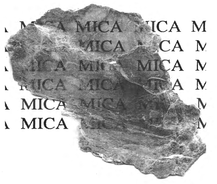
Transparent - Pick up a piece and look through it. The image above was formed by a direct computer scan of a piece of Springbrook Forest mica placed on top of paper with "mica" repeatedly printed. This piece of mica is about a sixty-forth of an inch thick at its thinnest.
Flexible - A thin piece can be bent back on itself.
Heat resistant - It is stable in a flame.
An electrical insulator.
Endlessly separable into thin flat sheets (Perhaps not quite endlessly, but ti can be split until a thickness of seventeen angstroms is reached).
The type of mica found in Springbrook Forest is Muscovite, so named because of its use for windows in Russia. Mysticism surrounds mica. Hindu legend says that mica is frozen lightning from thunderbolts thrown by Indra, King of the Gods, when he was fighting the demons.' In the U.S. mica decorations are found in Indian burial and temple mounds of Ohio and Tennessee. Some of these items are over two thousand years old.
In 1840 Francis Preston Blair and his daughter, Elizabeth, found a bubbling spring while riding on horseback in the woods beyond Washington. Rays of sunlight glittering on mica particles in the water caused Mr. Blair to name it "The Silver Spring". From this encounter Silver Spring acquired its name.
In 1867 prospectors looking for old Spanish silver mines discovered mica in North Carolina. The "silver mines" turned out to be ancient Indian mica mines. After these discoveries, a large mica industry developed in North Carolina".
By 1880 green corn fields were promising crowning plenty to Montgomery county. On the land that became Springbrook Forest there was a different promise, deposits of mica had been discovered.
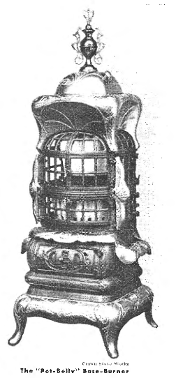
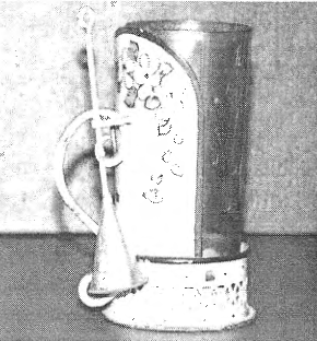
Because of its transparency and its resistance to heat, mica came into particular demand for "illuminating" heating stoves (Figure 3.1). This demand continued into the 1890's. Popular Science Monthly of this period said "The chief use of cut mica is in stoves, and its comparative cheapness has made possible the luminous - not to say - artistic wonders which constitute the latest and most cheerful creations of the stove men." Some expensive stoves had two-thirds of their radiating area ornately covered with mica windows. Mica was also used on lamps as a shade to protect their open flame (Figures 3.2 and 3.3).
With the large demand for mica in the mid 1800's, prospectors began to look for sources of mica outside of New Hampshire and North Carolina. In Maryland large quantities of mica were found in Howard County along the Patuxent river. In Montgomery County the only mica mine was in the future Springbrook Forest.
The Lee Farm was renamed the Mica Mine Farm in 1882 when the land was sold to Charles D. Gilmore and John H. Rice. In 1884 the Maryland Mica Mining Company was "substituted as purchaser." The 1883-1884 U.S. Geological Survey Annual Report states, "there has quite recently been a great deal of activity among mica miners in Maryland, especially in Howard and Montgomery County. One group of mines is located a few miles west of Laurel; and another mine, the Gilmore, is near Colesville, and only twelve miles north of Washington, District of Columbia. At the Gilmore mine there is a vertical shaft about 50 feet deep, and two horizontal tunnels; and a considerable quantity of good mica has been taken out. At present however, but little work is being done in this field." (Springbrook Forest is eleven and three-quarter miles north of the Capitol Building.)
A 1923 Geological Survey Bulletin states "A mine was worked from 1882 to 1884 on the southwest side of the Northwest Branch, 4 miles N 550 E of Kensington. It was then known as the Gilmore Mine. The mine was worked by an open cut 06 feet long, 51 to 25 feet wide, and 10 to 15 feet deep, driven S 350 W into a hillside, with a shaft and some underground work in the northeast end of the cut"?. The location referred to is Springbrook Forest.
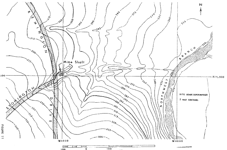
In 1968 as the first edition of the History was being researched and written, high school boys (including Eugene Beach, Jr. and George Misko, Jr.) scouted the area locating early property lines, remains of rutted wagon roads, and the mica ditches. In particular, the search for the shaft location was a special assignment. This should have been easy as the 1923 reports clearly gave the direction and size of the mica ditch in which the shaft was located (a trench sixty feet long, twenty five feet wide, fifteen feet deep) How could it be missed?. The date for publication of the history document grew near and still no one could locate the shaft position with certainty. Finally, one. month before publication an old weather-beaten "plane table" map was found at a surveying office in Silver Spring. It clearly showed a ditch meeting all the specifications of the 1923 description. From this ti became evident that the ditch and shaft had been filled with dirt in 1945 during the development of the subdivision. The location of the shaft was shown to be about twenty feet east of the intersection of Stonington and Remington, just about no the property line of lot K1. The portion of the plane table map that shows the shaft is reproduced in Figure 3.4.
Mr Gray who formerly lived on Grays Lane remembers from his childhood a tunnel (rather than a shaft) from which mica was removed. This tunnel was big enough to accommodate a four horse team. It was located in back of of lots G8 and G9. This may be one of the horizontal tunnels mentioned in the 1884 report. Mr Gray remembers that the mouth of the tunnel was filled in by Mr Moss' men in 1945.
Traces of old wagon ruts, deserted roads and "mica ditches" can be found throughout Springbrook Forest. Combining this information with our other sources Figure 3.5 shows the wide extent of the mining operations, including the ditches, tunnel and shaft - al sources of mica "books" (i.e. large chunks consisting of many layers of mica). The "Mica Mine House" provided living quarters for the miners. The stable was needed for the large number of horses used in the mining operations. At the trimming house (located "one-fourth mile NE of the mine on a ridge) the mica books were separated into thin sheets and then hand trimmed into a wide variety of standard sizes - the bigger the resultant sheet the greater the price per pound. For instance, at the time the Gilmore Mine was in operation a pound of two inch by two inch sheets would bring only about fifty cents, while a pound of six inch by six inch mica sheets would bring ten dollars.
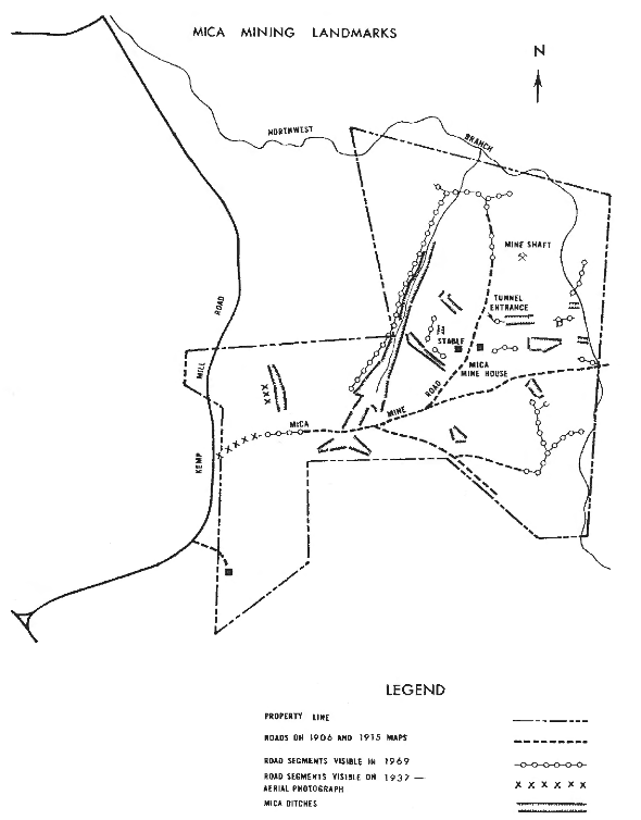
The principal road, known as the "Mica Mine Road" ran through the present back yards of houses along the south side of Stonington Road then, at the present Triangle, moved northward along Stonington Road.
Hard times hit the mine after 1884 - imported mica from India sold for less than the domestic product. The Gilmore Mica Mine changed ownership in 187 when the "Mica Mine Farm" was sold to Henry M. Baker - Gilmore, Rice and their Maryland Mica Mining Company having "failed to comply with the terms of sale" of 1884. The Maryland Geological Survey in 1897 said that the mica mines of Montgomery and Howard counties "are not at present worked".
The mica mine was evidently operated in a small way at the time of World War I, when mica was badly needed for radios and other electrical equipment. Mr. Gray can remember the mica mine, the mica house and the stables from before 1920. He tells of seeing teams hauling mica from the tunnel. A caretaker family named Alwalt who lived in the mica mine house is especially remembered. Sometime before 1920 the mica mine house burned down.
The previously mentioned 1923 Geological Survey Bulletin states "The Gilmore Mine is now owned by B. H. Warner, Jr. of Washington, D.C.". Mr. Warner was the son of the founder of the town of Kensington. During this post 1900 period the mine was called the "B. H. Warner Mine", the "Kensington Mica Mine" and the "Gremoses Mica Mine." . The reference to M.r Warner is puzzling as land records give no indication of B. H. Warner, Jr. ever owning land that became Springbrook Forest. A 1940 Plat (found in 1968 in the offices of surveyors Ben Dyer Associates) does, however, show the name "B. H. Warner" on Springbrook Forest land. Evidently Mr. Warner either had an option or a lease on the land from sometime after 1900. The 1923 Bulletin further states that "the shaft has caved badly".
On May 1, 1934 the Washington Post told about an upcoming trip of the of the Wanderbirds Hiking Club to the "old mica mines":
"The old mica mines near the Northwest Branch will be the goal of Sunday's trip. Leaving the highway a short distance below Four Corners, the club will follow a dirt road through the woods for a quarter of a mile and enter a trail just beyond the old Reed house. After crossing a field, the hikers will reach an excellent spring where canteens can be filed. About this spring may eb found some interesting salamanders. The trail now leads through a rich forest of oaks and tulip poplar, in which several species of orchids and members sf the lily of the valley family are liable to be found. Descending to the Branch, the group will reach the old mica mines. These old diggings furnished mica to local industries years ago. in searching through the debris, one can usually find a sizable slab of mica for his mineral collection".
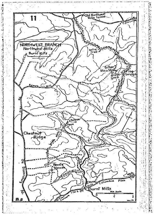
The Wanderbirds map (Figure 3.6) shows both the mica mine and the graveyard, the only map explicitly mentioning a graveyard. The name "Gilbert" is used instead of the correct "Gilmore".
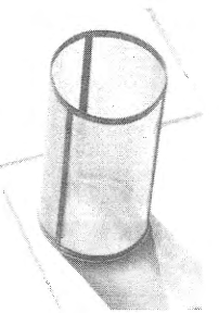
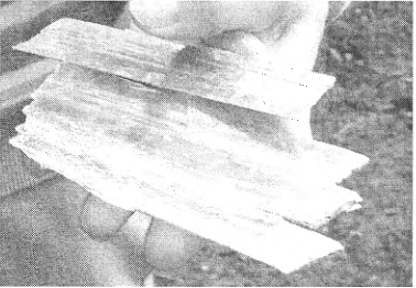
It is still true that at the mine site "one can usually find a sizable slab of mica". My grand daughter found the razor like pieces of mica (Figure 3.7) in the ditch near the shaft location on January 13, 2002.
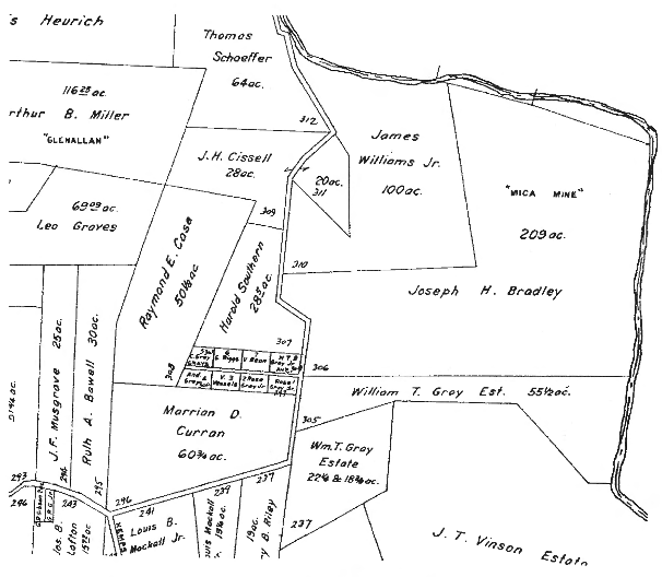
A real estate map published in 1937 (Figure 3.8) explicitly identifies Joseph H. Bradley holdings of 209 acres of land that later became Springbrook Forest as "Mica Mine".
There is no present production of sheet mica in the United States. The last North Carolina mine closed in the 1960's. Sheet mica, imported from India, is still in wide use as an electrical insulator, in particular as "spacers" in commutators for electric generators and motors, and as the dielectric for high quality capacitors.
Today some of the smaller mica ditches have been landscaped and are now attractive flower gardens. The children of Springbrook Forest find mica glittering on the ground after rain has washed the mud and dirt off its shining surface. Idly they peel off one layer after another. A trench is dug for a new sewer pipe and shovels full of mica appear. Although mature trees grow undisturbed in the old ditches, the memory of the Gilmore mine that operated over a century ago remains.