HISTORY OF
Settlers Arrive and Patent Land along Northwest Branch
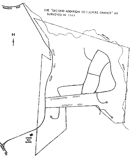
The Second Addition to Culvers Chance
The Patentees, The Settlers, The Farm Era: the Culver, Semmes, and Lee Families and Their Households — 1679 to 1882, and property exchanges to 1913
by Florence Howard (2002) and David H. Schaefer (1970)
Today Springbrook Forest occupies much of the land once known as The Second Addition to Culvers Chance. The Northwest Branch, the tributary of the Anacostia which borders our community, was an early attraction to this part of Maryland. On it were eventually located mills at several locations, one of which gave its name to Kemp Mill Road. This area has existed successively under the jurisdiction of four Maryland counties: Charles, Prince George's, Frederick and, since September 1776, Montgomery County. It was not until the late 1680's that land was granted by Lord Baltimore's land office in this part of Maryland. This was a wilderness place at that time beyond the frontier of European settlement. The lower Patuxent River, in what is present-day Prince George's County, but in 1679 still called Charles County, was a good location for beginning anew life in Maryland.
Maryland was unique in several ways. Its proprietor avoided conflict with the indigenous American Indians by purchasing land for the St. Mary's settlement at the colony's beginning. William Walsh and William Lloyd Fox, in their book, Maryland, A History (Hall of Records Commission, Annapolis, Md., 1983, page 5) explain:
"...friendly relations with the Indians of the neighborhood spared Maryland colonists the horrors of such massacres as Virginia experienced in 1622 and again in 1644... The single powerful tribe, the Susquehanna's on the upper Bay, was remote from the early settlements, and partly neutralized by awesome enemies, the Iroquois, to the north. Maryland tribes gradually dwindled or moved away, leaving only place names as their memorials: Nanticoke, Wicomico, Port Tobacco, Patuxent, Piscataway.
Almost feudal privileges had been granted to George Calvert, the first Lord Baltimore, a convert to Catholicism, who had earlier attempted to establish a colony in Newfoundland, but abandoned the idea because of the harsh climate. His subsequent visit to Virginia had encouraged him to seek rights to begin again in the more southern Chesapeake area. But he died in 1632 without ever visiting Maryland and only weeks before the charter he had sought was granted.
The charter of Maryland went to Cecil Calvert, the second Lord Baltimore on 20 June 1632, who saw the enterprise as a business venture with profit to be made. After a four-month voyage, the colonizer's ships, the Ark and the Dove landed on St. Clements Island, in the Potomac River on 25 March 1634. Lord Baltimore's brother, Leonard, was made governor with two commissioners and a council of men to advise him. The unique, almost feudal land system and government, which was established at the outset, remained in force until the American Revolution. At first, land was granted by the land office as "head rights" depending on the number of immigrants. Later, a fee, "caution" money, was charged for land grants. Grantees had to pay a "quit rent" yearly to Lord Baltimore's agents.
In 1679, a young man named Henry Culver sailed from London to Maryland on a ship, the Globe, with shipmaster, Samuel Groome, claiming a headright of 50 acres for each of the 40 passengers he imported that year. Within ten years of arriving in America Culver had married a widow with property and children for which he had to file court papers. During the fifty years from his arrival until he died he acquired property, married twice and raised a large family.[We shall see that this Henry Culver had a son named Henry who, in turn, named his son Henry. For clarity these will be designated as Henry (1), Henry (2), and Henry (3).
Henry (1) died in 1729. He stated he was "very sick" when he wrote his will on 7 February 1729. The will named his two sons, Henry (2) and William, and six daughters. Son William and the daughters were left ten [black slaves], who were listed by name, and who were to go to the daughters when the daughters reached 16, or day of marriage, and to William at age 21 years.
We need to acknowledge the important contribution of those early residents of provincial Maryland who were from areas of the world other than Europe, especially those from Africa. Although [enslaved or] pressed into involuntary servitude, their skills and labors contributed greatly to the success of the colony then largely an agricultural system whether working with the owner of a small farm working side-by-side, or under an overseer, who might also be in involuntary servitude, on on of the few larger landed estates. We have only the given names of the [black slaves] in the Culver household at that time. They were a boy named Ned who was to go to William Culver; a girl named Doll, to Mary Culver; to Sarah Culver, a girl named Jenny and a boy named Andrew; to Margaret Culver a girl named Bess and one boy, name not given; to Monica Culver, a girl named Sue and a child called Beck; to Ann and Elinor Culver, one girl named Lucy and one woman named Esther.
Prince George's County was established in 1696, and comprised all of Maryland west of the Patuxent River, a huge area. This new county included lands formerly patented as being in Calvert or Charles County. The population east of Northwest Branch had grown and settlers were pushing westward. Land speculators had sought new surveys and patents in the more western part of Prince George's County in the late 1600s.
The first patent in the area near present-day Springbrook Forest was "Saint Wynox Bergh" (Figure 2.1) surveyed in 1689 for Mr John Woodcock. This was one of the earliest tracts patented in what is now Montgomery County. The tract began at a bounded white oak, referred to in later surveys as "Woodcocks Tree," standing on the west side of the "North Branch of the Eastern Branch of Potomack by the side of a small Run that faleth into the said Branch above the head of a great Savanah running thence up the Branch." This important landmark was located about where the small stream that flows today under Kemp Mill Road south of Glenallan Avenue joins the Northwest Branch.
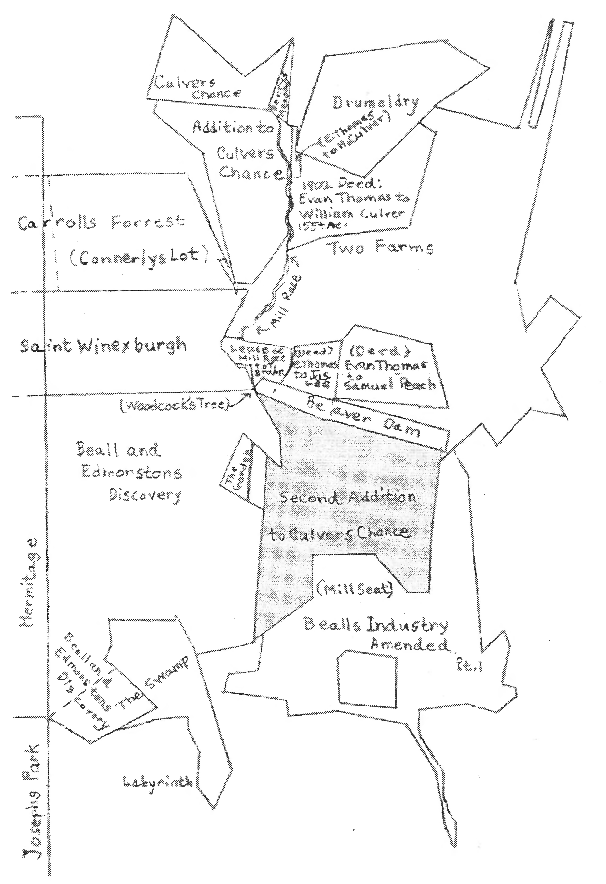
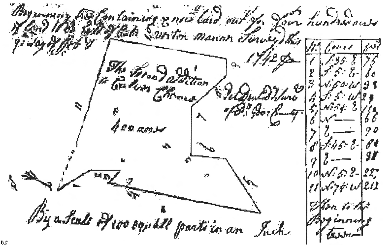
In 1742 (when George Washington was only a lad of ten) the Second Addition to Culvers Chance, a tract of 400 acres, was surveyed for Henry (3) Culver (Figure 2.2). He obtained a patent for the land in 1743. The Second Addition to Culvers Chance included all of what is now Springbrook Forest (see Figure 2.3). The Northwest point of the tract was the previously mentioned "Woodcocks Tree". It seems that the Culvers did not live on the tract, although some of them lived in the general area. Henry Culver paid 16 shillings (around $4.00)rent a year to Lord Baltimore.
The population of Prince George's County had increased so much by 1745 that a new county was formed out of the western part and named Frederick County. The dividing line was about where the line divides Prince George's County from Montgomery County today. So it is the Frederick County Debt Books for 1753 to 1759 which show that the Widow Culver was listed with the properties "Chance," "Addition to Chance" and "Second Addition to Chance", meaning Culvers Chance. Chance and Addition to Culvers Chance lay about where Indian Spring Country Club is now located.
Twenty years after the land was surveyed, Henry Culver sold the Second Edition to Culvers Chance to Joseph Simmes, a "planter of Charles County" on 12 February 1762 for 52 pounds and 10 shillings sterling (around $250 or about 50 cents an acre). A standard memo with the deed noted that Mary, wife of Henry Culver, "being privately conveyed..." agreed to wave her dower right to the property, "and declared that she did the same voluntarily and Freely without being compelled thereto by any threats of her said Husband or fear of his displeasure."
Exactly when the Simmes [Semmes or Simms] family was first living on Second Addition to Culvers Chance is not known. They are not found in the 1776 census, as the list for Rock Creek Hundred is missing. It was in 1776 that Montgomery County, previously identified as "Lower Frederick County," was established. And in 1777, Joseph "Simms" was listed in Rock Creek Hundred with four "taxables", apparently himself, his wife and two children.
The 1783 Assessment enacted by the Maryland General Assembly to raise money to help pay for the Revolutionary War showed Joseph Simms had 371-3/4 acres valued at 417 pounds, 18 shillings and 9 pence. His land was improved with one "Log Dwelling house, 2 framed Tobo. houses and other Log'd buildings; 100 acres cleared, 5 acres meadow in grass, 3 acres Marsh Timber'd Land." The list of personal property for which Semmes was assessed included 2adult slaves, a man and a woman, and six children. The Semmes family were also assessed for five horses and 10 cattle. Their own family consisted of nine "white inhabitants."
Following the American Revolution, landholders no longer had to pay "rent" to Lord Baltimore or his agents. The first mention of the Second Addition to Culver's Chance after the Revolution is a 1786 resurvey for Joseph Simmes. The surveyor appears to have been trying to make corrections to what he thought were earlier errors. In this resurvey, the surveyor stated that he found that part of The Second Addition to Culvers Chance lay foul to an elder tract called "Discovery", (Beall and Edmonstons Discovery) and so lost some acreage. in order to make up for the lost acres, he tried to add a long projection at the northwest corner of the tract, believing vacant land lay there (Figure 2.4).
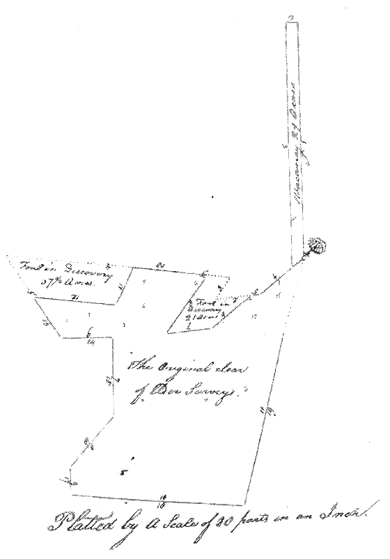
The 1786 resurvey shows the altered lines. However, the Land Office, which continued to process surveys and patents after the Revolution, to the present time, found the resurvey unacceptable and no patent was issued. The resurvey is interesting in that it identifies some surrounding patents. The tract referred to as "Discovery" was "Beall and Edmonstons Discovery" which fit perfectly to the west of Second Addition to Culvers Chance, except for the small area patented as "The Garden", about where Alpert Lane goes into Wheaton Regional Park today.
To the west of Beall and Edmonstons Discovery was The Hermitage, patented in 1689 for 3,866 acres. The line between these two tracts can be seen on today's maps as the western edge of Wheaton Regional Park. A person crosses that line when using the Shorefield Road entrance to the Park. The name Shorefield is a corruption of Shaw field, the name of the part of Beal and Edmonstons Discovery where the Moses Orme family lived and which was later sold to the Stubbs family, whose early 1800's home is still there. To the north of Beal and Edmonstons Discovery was Saint Winexburg.
Before his death in 1792 Semmes had given his son, Joseph Milburn Semmes, 10 acres in the northwest corner of the Second Addition to Culvers Chance. Most of this land is now Kemp Mill Forest.
Joseph Semmes, Sr. died intestate on 12 December 1792. It was ten years before his estate was settled. In the meantime Joseph Milburn Semmes had died leaving 2 sons and a daughter. In an Equity Case filed in order to settle the estate of Joseph Semmes, Sr., the Court named commissioners who determined that dividing the land equitably for all heirs was not feasible. The case, covering many pages, is recorded in a volume in the courthouse in Rockville entitled Court Records 1801 - 1806 Insolvent Records 1807 - 1823. The land had to be sold and the proceeds divided among the heirs, some of whom were minor children. The Commissioners were to give four weeks notice in The Washington Federalist and National Intelligencer of the time, terms and place of the sale. An advertisement appeared in the Washington City newspaper, The National Intelligencer and Washington Advertizer, on Wednesday, 15 October 1802 announcing that the Simmes property would be sold on "Monday the 25th of October, next, if fair, otherwise the next fair day, no the Premises to the highest bidder on a credit of one, two, three and four years, with interest to be paid annually from the date -- All the right, title and Effects of JOSEPH SIMMES, deceased, to a certain tract of land, called the Second Addition to Culvers Chance, containing 300 acres, lying on a stream of water called the North West, and in Montgomery County, now in possession of his widow, Catherine Simmes." The name is variously given as Semmes, Simmes, and Simms'.
At the auction the land was finally "knocked down" to Mr Nathaniel Wilson at $12 per acre. This was not all of the land that Simmes had purchased from Henry Culver in 1762. There was a question of the exact acreage since 100 acres had been given to the eldest son, and also there was the widow's dower. To determine the exact metes and bounds Wilson asked that a new survey be made. That survey was recorded in detail and shows three houses on the whole tract, with four divisions. A copy of the colorful survey plat was shown on the cover of the History of Springbrook Forest and Second Addition to Culvers Chance of April 1970. Two copies of this plat appear in the volume at the courthouse in Rockville. Permission to copy the plat was granted by the Officers of the Court of Montgomery County for the present edition of the History and is included as the color insert [here].
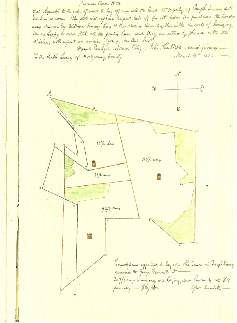
Mr Wilson's resurvey of Second Addition to Culvers Chance was made by George Fenwick, Jr., "of the County of Washington," a surveyor hired by the Court, who found Wilson's part to contain 286-2/3 acres. The claimed 1786 "vacant land" is nowhere to be seen. Red outlines the original tract (The Second Addition to Culvers Chance). Blue indicates the boundary lines of Beall and Edmonstons Discovery as shown on the 1786 resurvey, however in a slightly different position. Green indicates the "woodland". The commissioners reported on 14 May 1803 that all parties were extremely pleased with the division.
Three houses are shown. The most northern house is where the Naham's house was located, now the site of Kemp Mill Overlook. The eastern most house is in Springbrook Forest on the lower part of Stonington Road. This general location for a house is also noted on later maps. The third house is close to where the old Curran house was located, on what is now Kemp Mill Farms.
Nathaniel Wilson's purchase of about 280 acres is shown in Figure 2.5. Here, land claimed by "Discovery" has been removed, as well as the previously mentioned northwest corner of the tract.
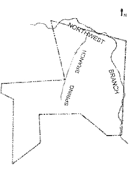
Mr Wilson's ownership of the land only lasted a short time, for by 1810 Mr. James Le had gained ownership. The property became known as the "Lee Farm." The land was described as starting "at a bounded post standing on the side of a hill and on the west side of the Spring Branch." The position described is near Brookhaven Drive at the point where the Jackson- Sacks (Lot 7, Block C, 501 Rockford) and Nelson (Lot 1, Block N, 12200 Brookhaven) property lines would meet if continued into the right of way of Brookhaven Drive. The "Spring Branch" evidently flowed along what is now Brookhaven Drive and on into the Northwest Branch as it does today. James Lee paid $3360 for the 280 acres - the $12.00 an acre price. In 1837 the farm cam into possession of James Lee, Jr.
The population of Montgomery County in 1810 was 17,980. By 1840 it had decreased to 15,496. "Continual planting of tobacco had worn out the soil. Farm lands held no promise and younger people moved elsewhere. By 1840 the traveler from one farm to the next found the same broken fences, homes in need of repair, everywhere a general atmosphere of disillusion and abandonment. Montgomery County had come to be called the 'Sahara of Maryland'"10 The Quakers of Sandy Spring introduced Peruvian guano into the county in 1844. This fertilizer rejuvenated the land and, with the abandonment of tobacco culture, fertility of farmland was gradually restored.
The United States 1850 Agricultural Census showed the Lee Farm with 100 acres improved and 180 acres unimproved, with a cash value of $1500. The value of farming implements and machinery was listed as $80. There were 3horses, 7"Milch Cows," 1other cattle, 16 sheep, and 18 swine with the livestock valued at $280. For crops, there were 75 bushels of wheat, 400 bushels of Indian corn, and 330 bushels of oats. Also, 5 bushels of Irish potatoes, 260 pounds of butter, and 6 tons of hay were produced on the farm. The value of animals slaughtered was $70. There was no listing for tobacco.
The 1855 Montgomery County Assessment Record listed James Lee Jr. with 289 acres for part of Second Addition to Culvers Chance valued at $6 per acre with a total value of $1734 for land and improvements. Livestock was valued at $345, household furniture at $110, and Plate at $16, for a total value of $471 for Personal Property.
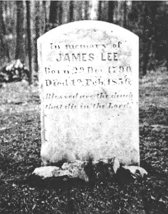
Just as better times were coming in 1856, James Lee, Jr. died. He was buried in a family graveyard located (according to Mr. William T. Gray) half on property now owned by the Paglins (210 Stonington) and half on the Misko property (12210 Remington). James Lee's tombstone is shown in Figure 2.6. This stone was found by Mr. Hembree in back of his home on Grays Lane. He generously donated it to Springbrook Forest.
The will of the younger James Lee, who was not yet 20 years old in 1810, listed his wife, "Leathy," executor". The 1860 census showed "Leathy" Le had 20 acres of improved land, and 73 acres of unimproved land. The Montgomery County Assessment book for the Fifth District for 1866 listed Mrs. "Lethe" Le with 289 acres of Second Addition to Culver's Chance valued at $5.78 per acre, for a total value of $5,780 for which she was assessed $20. Martinets Map of Montgomery County published in 1865 is shown in Figure 2.7.
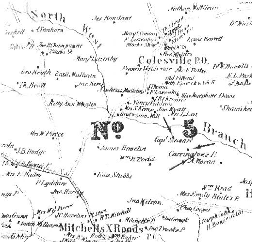
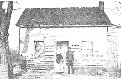
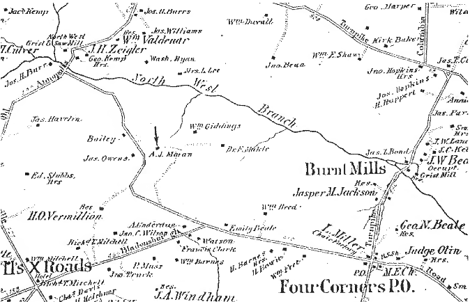
Note the "Grist and Saw Mill" on the map next to Mrs. S. Kemp" at the present Randolph Road and the Northwest Branch. Like the 1803 map, three houses (indicated by arrows) are shown within the bounds of the Second Addition to Culvers Chance. One appears to be occupied by aCaptain Stewart, a second, within Springbrook Forest, by someone named Carrington, and a third house is shown just above the "A" of "A. Moran." Mr William Gray's grandmother was a Moran and he has told of two Moran homestead locations, both of which are shown on the map. The one to the right of "A. Moran" is located where the Kemp Mill Recreation Center now exists. The one above the "A" is between the houses known as the "Yeatman and Auth houses", beyond the former Spring Mill School, now an Area Office of Montgomery County Schools. A photograph of the Moran homestead, taken about 1930, is shown in Figure 2.8. Mr Gray's parents are standing in front.
Mr Moran's "Homestead" near the Spring Mill office complex is shown on an 1879 map (Figure 2.9). Kemp Mill road, unnamed, appears for the first time on a map. It has all its present curves and turns. The Northwest Grist and Saw Mill is shown as two buildings, both east of the Northwest Branch, one north and the other south of what is shown as Old Annapolis Road, now Old Randolph Road. Mitchell's Cross Roads is at the present intersection of University Boulevard, formerly Old Bladensburg Road, and Georgia Avenue, formerly the Brookeville Pike.
By 1880, the green cornfields were promising crowning plenty to Montgomery County. On the Lee's farm, however, there was a different promise. Mica had been found. The "Lee Farm" became the "Mica Mine Farm" in 1882 when the land was sold to Charles D. Gilmore and John H. Rice. This ended the farm era for what was to become in future years Springbrook Forest.
In 1887 the "Mica Mine Farm" was sold to Henry M Baker; Gilmore, rice and their Maryland Mica Mining Company having "failed to comply with the terms of sale" of 1884.
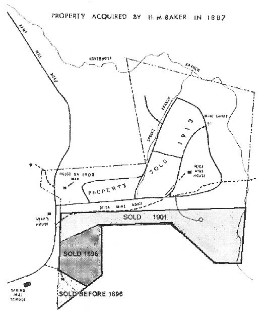
Henry Baker over the years sold parts of his tract as shown in Figure 2.10. Ten acres at the southern tip of the property were sold to Andrew J. Moran some time before 1896. This brought the Moran "Homestead" under the ownership of Mr. Moran. In 1896 twenty-two adjoining acres (now comprising Waterford Downs) were also sold to Mr. Moran. In 1901 the present Mr. Gray's father purchased 55 acres of land north of Mr. Moran's property. This tract contains the lots on both sides of Hermleigh Road between Kemp Mill road and Auth Lane, all lots directly north of Hermleigh Road, all of Viewcrest, and all of Mansions in the Woods. Mr Baker kept the northern portion of the property consisting of 209 acres. Spring- brook Forest is contained in this 209 acre tract.
At the turn of the century the Forest was full of chestnut trees and the Bean and Gray families picked and sold chestnuts. In the early 1900's chestnut tree blight hit the area and by 1920 most of the chestnut trees had died. The land was alive with game. Fox, raccoon and wild turkey hunting were popular. At the Northwest Branch fish could be caught under the winter ice and a boy could come home with a burlap bag bulging with fish.
In 1913 the 209 acres of Henry Baker were sold to Charles D. Smith and Joseph H. Bradley. Smith and Bradley were partners who owned the Columbia Sand and Gravel Company.
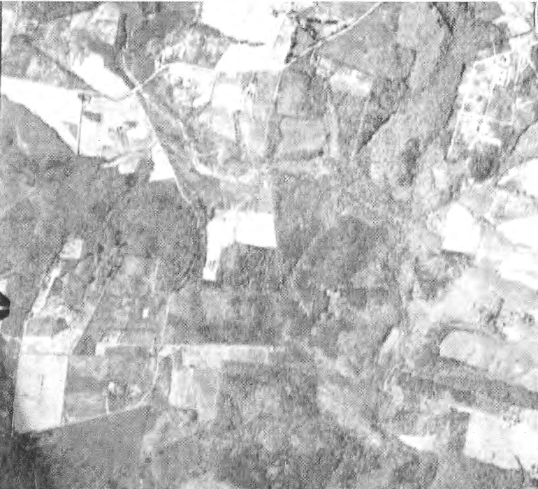
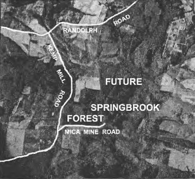
Figure 2.11 is the oldest known aerial photograph of the Springbrook environs. This view of what was to become Springbrook Forest was taken April 30, 1937 at 4:00 in the afternoon.Springbrook Forest land is located below and to the right of the white area (a field) located at what is now Kemp Mill Forest. Kemp Mill Road can be seen at the left and Randolph Road at the top of the photograph. Grays lane is the straight line going west from Kemp Mill Rd.
The Mica Mine Road led to the mica mining operations that will be discussed in the next chapter. The Mica Mine Road's beginning can clearly be seen to the east of Grays Lane, and its wandering into the Forest can just be made out. The mica ditches (to be discussed in the following chapter) and elsewhere show as bright areas among the darker trees.
The forested hillsides today make it difficult to realize that for over 100 years this area was farmed and had supported several large families. But changes were to take place that vastly altered the terrain.