HISTORY OF
The Prehistory of Springbrook Forest and Vicinity
by Phillip J. Hill, Ph.D (2002)
Since at least 1970, the residents of Springbrook Forest have been compiling a history of their community which dates back to the first half of the 18th century. Springbrook Forest also has a prehistoric past, although it is much more obscure. In January of 1997, I decided to change this uncertainty by conducting an archeological investigation of a rockshelter, referred to locally as
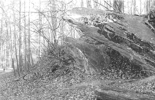
"Shell Rock," situated adjacent to the northeastern corner of the Springbrook Forest community limits (Figure 1.1). Presumably, if prehistoric people once occupied this rockshelter, then it would be a reliable source for describing Springbrook Forest's pre-European past as well. Shell Rock is herein referred to as the "Northwest Branch Rockshelter."
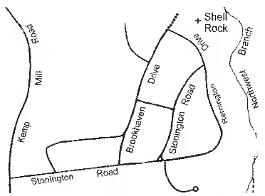
The Northwest Branch Rockshelter is located within Northwest Branch Park, adjacent to Springbrook Forest (Figure 1.2). The rockshelter sits about 100 feet from the levee of Northwest Branch, a perennial tributary of the Anacostia River which flows through the District of Columbia and eventually empties into the Potomac River The shelter forms part of the base of a ridge that runs parallel to the stream. Presumably the shelter itself was exposed as early as 5,000 years ago by an earlier history of alluvial down-cutting and eventual movement eastward of Northwest Branch.
The Northwest Branch Rockshelter is frequently visited by local residents, especially the young residents of Springbrook Forest. The beer cans, broken bottle glass, and fire remains under this massive rock structure are clues as to its current use (Figure 1.3). Archeological testing suggests that perhaps the rockshelter's use in the past and present were not altogether different.
In January of 1997, the Northwest Branch Rockshelter was initially tested using a one-and-one- half foot excavation unit (Figure 1.4). This unit acted as a window into the past to determine whether the shelter was ever occupied by prehistoric folks. Presumably the nature of the shelter itself and the natural setting surrounding it would have been an attractive place to visit. After digging for two days through modern beer glass and charcoal and an additional three days through sandy soils no evidence was initially observed to suggest a prehistoric presence.
It was not until these excavated soils were more thoroughly inspected back at my lab that I realized that the Northwest Branch Rockshelter contained prehistoric artifacts and was in fact a prehistoric site. Because the artifacts recovered were rather limited in what they could tell me about the area's prehistory, it was clear that further testing was required. Prior to a subsequent examination of the rockshelter, the site was registered with the Maryland Historical Trust in Crownsville, Maryland. The site inventory number assigned was "18M0458."
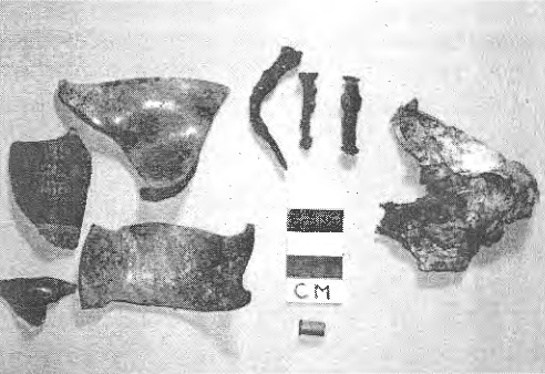
In March of 1997, the test unit excavated back in January was expanded into a 3-foot square. This larger unit allowed me to excavate twice as deep as before and examine a greater portion of the shelter's floor. At the completion of twelve days of testing, the unit was excavated to a depth of nearly four feet until resistant rock was reached and digging was halted. As expected, the expanded unit yielded many more artifacts than previously found with the potential of addressing many questions regarding the prehistory of Springbrook Forest and the nearby vicinity. The prehistoric material recovered at the rockshelter consisted of lithic artifacts (stone), pottery, bone, and charcoal.
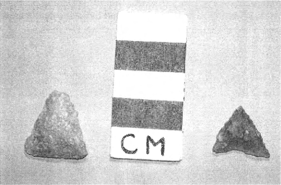
A number of the artifacts found are what archeologists commonly refer to as "temporal diagnostics." In other words, they can answer questions about the rockshelter's period of occupation. These artifacts included two projectile points (arrow heads in this case) and a few pieces of pottery or "pottery sherds." The two points are small in size, isosceles in shape, and made from local quartz and quartzite (Figure 1.5). Both artifacts belong to the same cultural time period known as the "Late Woodland."
The Late Woodland period began about 1,100 years ago and lasted about 700 years up until the point of European contact in the early 17th century. In the Middle Atlantic region, this time period was distinguished from earlier times by the introduction of plant domestication; the diffusion of bow and arrow technology into the area; and the presence of permanent farming communities along major river flood plains, such as with the Anacostia and Potomac rivers. The Late Woodland was also marked by population increase, territorialism, and open hostility between culturally and/or geographically distinct groups, particularly between those residing in the eastern Coastal Plain and western Piedmont physiographic provinces.
Nearly all of Montgomery County is situated in the Piedmont. Therefore, it is more likely that the Northwest Branch Rockshelter and vicinity were occupied by local Piedmont people during the Late Woodland. Territorialism and open hostility between groups would have all but eliminated long distance travel by eastern Coastal Plain and western Blue Ridge/Ridge and Valley folks. Because they generally occupied permanent farming settlements on major river flood plains, interior settings such as at the Northwest Branch Rockshelter would have been used as temporary base camps or short-term habitation locations during periodic hunting and lithic material procurement forays. The lithic waste and burned bone fragments recovered with these Late Woodland points support this interpretation. Particularly corroborative is the high frequency of small size waste flakes found. Such are commonly found at habitation sites where late-stage projectile point manufacture and projectile point resharpening or tool maintenance occurred. The lack of pottery dating to the Late Woodland indicates that occupation of the shelter at this time was perhaps more short-term and rather specific in focus, i.e. hunting-related. This may be related to the shelter's close proximity to the Fall Zone acting as a buffer between Piedmont groups and those residing further east.
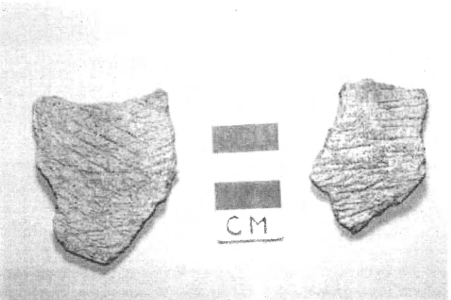
The archeological evidence indicates that the Northwest Branch Rockshelter was occupied earlier than 1,100 years ago as well. This is based on the presence of Accokeek-type pottery that dates from the late Early Woodland to the early Middle Woodland periods (Figure 1.6). This means that the rockshelter was occupied sometime between 2,800 and 2,300 years ago. In the Middle Atlantic region, this cultural time period was quite distinct from the Late Woodland. A sedentary pattern of living and the use of pottery were at their infancy. Bow and arrow technology was unknown and the spear was the major hunting implement. Although major floodplain settings were still an important settlement area, they were not planted in corn and other cultigens, for plant domestication had not yet been introduced. Local populations were expanding at lower rates, restricted territories and open hostility were altogether nonexistent, and groups freely moved between the Coastal Plain and the Piedmont regions. Major floodplain settlements were semi-permanent. Groups were generally less sedentary than the later Late Woodland folks because they had to respond to the geographical incongruity of seasonal foods, such as seeds, nuts, fish, and shell fish that they were dependent on.
Occupation of the Northwest Branch Rockshelter roughly 2,500 years ago was perhaps connected with the seasonal movement of folks exploiting known resources between the Potomac and Anacostia rivers and the interior tributaries of these rivers. The Fall Zone where the Coastal Plain and Piedmont regions overlap was particularly rich in edible resources. Perhaps the lower order streams such as Northwest Branch served as important hunting areas during lolls in seasonal fishing and shellfish collection at and below the Fall Zone.
The presence of pottery, lithic waste, and burnt animal bone at the rockshelter is indicative of a temporary base camp location during this time period as well. The recovery of pottery, however, suggests that this Early to Middle Woodland occupation had a more generalized activity focus and perhaps was of a longer duration than that of the later Late Woodland occupation. Both Woodland occupations contain similar evidence of stone tool manufacture and maintenance related to hunting activity.
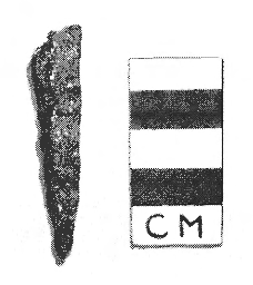
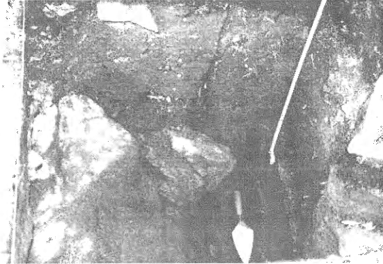
Archeological evidence also indicates that the Northwest Branch Rockshelter may have been occupied as early as the Late Archaic period. This period began about 4,500 years ago and ended 1,500 years later with the advent of pottery. The evidence to support this earliest occupation period, however, is rather limited. It is based on the recovery of a long, narrow stone drill made from quartzite found ten inches below the earliest excavation level containing pottery (Figure 1.7).
During the Late Archaic, the environment was relatively hot and dry in comparison to today. Prehistoric groups were thus attracted to aquatic settings such as Northwest Branch. Although not temporally diagnostic, they commonly used quartzite material to manufacture their spear points. Such points, referred to as "broad spears," were characteristically large and often recycled into other tool types such as the drill. Because this drill was found nearly a foot below the earliest pottery level, perhaps it marks the presence of a Late Archaic occupation. These folks were quite similar in their settlement and subsistence patterns to that of the Early/Middle Woodland people, although they must have been less sedentary as evidenced by their pre-ceramic level of technology. It is, therefore, reasonable that the one occupation would be found below the other.
No evidence was recovered from the Northwest Branch Rockshelter to suggest that the Springbrook Forest area was occupied any earlier than 4,500 years ago. It is likely that this lack of evidence is connected with the fact that the rockshelter was unexposed before this point in time. Archeology in Maryland has clearly shown, however, that prehistoric groups were present as early as 12,000 years ago. It is certainly plausible to assume that various groups moved in and out of this portion of Montgomery County during the 7,500 year period that remains unaccounted for archeologically in the area surrounding Springbrook Forest.